
Helping You Manage The
2024 Hurricane Season
Free Resources
WheelHouse IT is dedicated to regularly providing you with up-to-date resources
and tips to help support you, your business, and your clients this Hurricane Season.
")


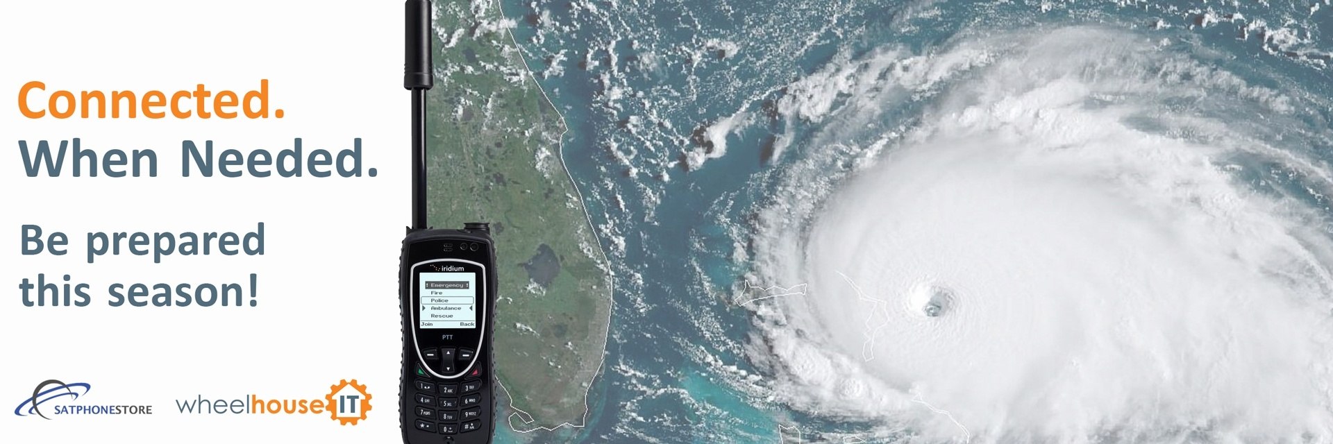
Rent a satellite phone
The 2024 hurricane season updates will be below
Real-time storm response updates
Whoo! There are no storms that are threatening our coverage areas. This is great news! But that means you can take this quiet time and review your preparedness plans. Once a storm forms and there is a threat, check back here for real-time updates.
Warm regards,
WheelHouse IT Storm Team
General updates
WheelHouse IT takes pride in the planning for the 2024 Hurricane Season. While we don’t want a disaster to strike any of our coverage areas; if one does we pride ourselves in being prepared.
With that said – you are encouraged to complete an audit of your top four primary points of contacts. Please click here to complete this audit.
Hello,
It’s not breaking news that June 1st kicks off the official start to hurricane season, and while we don’t know what to expect, do know that WheelHouse IT is ready for anything.
At this time we would also like to remind you to be on the lookout for “bad actors” targeting potential disaster victims and charitable donors following a hurricane. These generally come by way of fraudulent emails – often containing malicious links or attachments, and are commonly circulated after major natural disasters. Please remember to exercise caution when handling emails with hurricane related subject lines, attachments, or hyperlinks. In addition, be cautious of social media pleas, texts, or door-to-door solicitations relating to severe weather events.
We wish you a safe hurricane season and invite you to visit our 2024 Storm Resource center by visiting: https://www.wheelhouseit.com/storm/ (Not comfortable clicking the link? Simply copy and paste into your browser.
When a hurricane is forecast to strike an area, the focus is generally on the storm’s impact on residential areas, not commercial areas and businesses. WheelHouse IT continues to look at a larger picture of being prepared for the next disaster.
As a Ready.gov accredited company, WheelHouse IT understands businesses are just as likely to suffer physical damage and that they may experience data loss and a decrease in clients following a hurricane or tropical storm. To help avoid those problems, they endeavor to aid any business that wants to actively prepare for hurricane season with complementary information and hurricane preparation services.
Staying Informed with WheelHouse IT
The most critical steps that any business can take to survive adverse weather are obtaining information and remaining vigilant. It sounds simple, but many companies do not perform these steps. WheelHouse IT has worked with many businesses from Florida to New York to help get them ready if a hurricane or other powerful storm heads their way.
The company has created a free Hurricane Resource Center that includes various resources and checklists that can help you prepare, a frequently updated storm tracker, and a post-storm survey to evaluate a storm’s impact on your business.
The information within the Hurricane Resource Center is diverse. It includes a preparation checklist, hurricane warning business tips, communications templates to help you effectively reach out to your company stakeholders with updates, and emergency contact numbers in the South Florida region. These documents help with long-term preparation, facing imminent threats, and recovering once the storm has passed.
Active Mitigation
Staying informed during Hurricane Season is something every company should do, but that’s only half of the equation, according to WheelHouse IT. Businesses can take preventative measures to mitigate the risk to their company actively.
The most important thing that a business can do to keep information safe is to invest in cloud services. By working with WheelHouse IT, a Gold Microsoft partner, any company can begin backing up their valuable data online so that damage to physical servers will not result in data loss. Using cloud-based storage, Microsoft Azure, and Microsoft 365, every business can establish internal and external communications following storm damage. WheelHouse IT has proven to be highly effective in migrating companies 100% into the Azure cloud.
Another form of active mitigation is ensuring that there are lines of communication in one’s business insulated from disaster. Communications based on the internet and cell towers are typically the first thing to go in a major storm. Working with WheelHouse IT allows businesses to buy or rent satellite phones from Atlantic Radio Telephone for use in a storm’s aftermath. These phones help business owners get reliable calls from people on the ground to assess the damage and determine what is needed to get up and running again.
WheelHouse IT backs up their suggestions with actions, too. They are an accredited Ready.gov company, meaning they have been independently certified to be prepared for disasters. That means these systems and services will remain operational during or quickly following a hurricane, allowing customers’ IT systems to recover from the damage as soon as possible.
The speed at which a business recovers following a hurricane is entirely dependent on the measures put in place to reduce the potential losses. WheelHouse IT offers clients the opportunity to receive information about impending storms, help establish Cloud profiles, prepare guidelines for specific storms, and provide IT support in the immediate aftermath of hurricanes. This total solution for hurricane help can do it all for your business, but it’s up to small and medium business owners to take advantage of these offers.
You can learn more about WheelHouse IT by visiting their website www.wheelhouseit.com – their team is dedicated to business continuity solutions to ensure you can keep running. Even after a disaster!
Residents living along the East Coast should prepare for an above-average hurricane season between June 1st and November 30th, 2022. To learn how to achieve this successfully, we’ve created a comprehensive hurricane checklist that’ll guarantee you and your family are ready if evacuation is needed.
On the East Coast of America, hurricane season (Jun 1 – Nov 30) is approaching. Make sure you’re prepared by reading this comprehensive hurricane checklist.
What are the hurricane predictions for 2022?
On April 7th, 2022, scientists at the Colorado State University (CSU) said there could be at least 19 named storms and nine hurricanes this season. To visualize this better, see the below table.
Forecasted Parameters | CSU Forecast for 2022 | Average for 1991 – 2020 |
Named Storms | 19 | 14.4 |
Named Storm Days | 90 | 69.4 |
Hurricanes | 9 | 7.2 |
Hurricane Days | 35 | 27 |
Major Hurricanes | 4 | 3.2 |
Major Hurricane Day | 9 | 7.4 |
Accumulated Cyclone Energy+ | 160 | 123 |
Source: Colorado State University
To put this into perspective, on an “average” season, we’re typically confronted with 14 named storms and seven hurricanes. Therefore, 2022 will undoubtedly be an active season compared to previous data.
Including the above, major hurricanes (category three or high) have increased slightly. Between 1991 and 2020, these averaged 3.2 per year. However, in 2020, the CSU has forecasted this at 4.
But you’ll want to take these forecasted predictions with a pinch of salt. In 2021, scientists predicted only 17 named storms and 4 major hurricanes. But it resulted in the third most active season, which showcased harsher weather than suggested.
2022 is looking like the most active hurricane season to date, but why? Hurricanes develop from two weather elements: water temperature from the ocean and thunderstorms.
Because of climate change, our global sea-surface temperatures are rising. From this occurring, it ignites the cyclone’s energy further, resulting in a higher frequency of hurricanes and storms.
According to FEMA, 40% of businesses don’t reopen after a disaster such as a Hurricane. Therefore, becoming knowledgeable on this step-by-step hurricane evacuation packing list and tips is essential to ensure optimal safety and business continuity.
When implementing the below, always remember to action this sooner rather than later. This way, when a tropical cyclone develops during the Atlantic hurricane season, you can evacuate efficiently.
- Make a plan – First, make a base plan before considering anything else on this hurricane checklist. On the East Coast, hurricane season is between June 1st and November 30th. Therefore, planning before this is necessary. Some things you want to include are an emergency supply kit, phone numbers, nearest shelter location, etc.
- Have supplies – Have adequate supplies required to live and maintain health; food, water, medicine, power sources, essential documents, safety equipment, and personal items.
- Understand hurricane terminology – On Weather services or the news, there are two hurricane terminologies they’ll use: watch and warning. A hurricane watch suggests that 74mph or higher winds might present themselves in a location. In contrast, a warning suggests it’ll affect that area.
- Have transport ready – Before the storm gets expected, get transport ready. Have a car or truck full of gas, get supplies in there, or place your vehicle somewhere safe if you’re not using it.
- Get family and pets prepared – Go over your hurricane evacuation packing list and plan to ensure all family members understand the required actions. Also, get pets ready for transport or into a safe area.
- Secure your home – Don’t leave your home underprepared. Ensure there isn’t any loose yard furniture outside, cover up windows, secure doors, and place sandbags if a heavy storm gets predicted.
- Be prepared at all times – When you initially find out a hurricane is approaching, get prepared right away. Weather reports aren’t 100% accurate, so the harsh conditions could arrive sooner than you think.
Without question, if you prepare the above hurricane evacuation packing list and develop a solidified plan before the event happens, you increase the overall safety significantly.
The hurricane resources you must know
Before the National Hurricane Center confirms a severe weather warning, knowing valuable hurricane resources before the event is essential.
In the Hurricane checklist above, we mentioned anything required to prepare for this situation adequately. However, you’ll also want to become familiar with the below hurricane resources.
- After a storm – Two resources you’ll want to memorize are the NEDCC Collections Emergency Hotline and American Institute for Conservation’s National Heritage Responders for storms; both will provide free help from professionals in emergency responses.
- After a hurricane or flood – Lastly, for a hurricane or flood, you’ll want to become knowledgeable on this FEMA document: After The Flood: Advice for Salvaging Damaged Family Treasure. Without question, this is the most comprehensive guide available online that’ll tell you the required steps to revitalize your personal belongings after a flood or hurricane.
Online, the available hurricane resources are endless. However, you’ll want to take advice from government-backed or weather professionals. By following their guidance, you can ensure optimal safety. Therefore, become knowledgeable on the above and regularly update yourself.
Conclusion
After reading the above, you should have a comprehensive understanding of a complete hurricane checklist, from predictions, preparation, to resources. Now you know this, educate people around you and prepare for the 2022 hurricane season.
Advisory:
Official information issued by tropical cyclone warning centers describing all tropical cyclone watches and warnings in effect along with details concerning tropical cyclone locations, intensity and movement, and precautions that should be taken. Advisories are also issued to describe: (a) tropical cyclones before the issuance of watches and warnings and (b) subtropical cyclones.
Center:
Generally speaking, the vertical axis of a tropical cyclone, usually defined by the location of minimum wind or minimum pressure. The cyclone center position can vary with altitude. In advisory products, refers to the center position at the surface.
Direct Hit:
A close approach of a hurricane or tropical storm to a particular location. For locations on the left-hand side of a tropical cyclone’s track (looking in the direction of motion), a direct hit occurs when the hurricane or tropical storm passes within a distance equal to the cyclone’s radius of maximum wind. For locations on the right-hand side of the track, a direct hit occurs when the hurricane or tropical storm passes within a distance equal to twice the radius of maximum wind. Compare indirect hit, strike.
Eye:
The roughly circular area of comparatively light winds that encompasses the center of a severe tropical storm or hurricane. The eyewall cloud either entirely or partially surrounds the eye.
Eyewall / Wall Cloud:
An organized band or ring of cumulonimbus clouds surround the eye or the light-wind center of a tropical storm or hurricane. Eyewall and wall cloud are used synonymously.
Extratropical:
A term used in advisories and tropical summaries to indicate that a cyclone has lost its “tropical” characteristics. The term implies both poleward displacement of the cyclone and the conversion of the cyclone’s primary energy source from the release of latent heat of condensation to baroclinic (the temperature contrast between warm and cold air masses) processes. It is important to note that cyclones can become extratropical and still retain winds of hurricane or tropical storm force.
Hurricane:
A tropical cyclone with the maximum sustained surface wind (using the U.S. 1-minute average) is 64 kt (74 mph or 119 km/hr) or more. The term hurricane is used for Northern Hemisphere tropical cyclones east of the International Dateline to the Greenwich Meridian.
Hurricane Local Statement:
A public release prepared by local National Weather Service offices in or near a threatened area giving specific details for its county/parish warning area on (1) weather conditions, (2) evacuation decisions made by local officials, and (3) other precautions necessary to protect life and property.
Hurricane Season:
The portion of the year has a relatively high incidence of hurricanes. The hurricane season in the Atlantic, Caribbean, and Gulf of Mexico runs from June 1 to November 30.
Hurricane Warning:
An announcement that sustained winds of 64 knots (74 mph or 119 km/hr) or higher are expected somewhere within the specified area in association with a tropical, subtropical, or post-tropical cyclone. Because hurricane preparedness activities become difficult once winds reach tropical storm force, the warning is issued 36 hours in advance of the anticipated onset of tropical-storm-force winds. The warning can remain in effect when dangerously high water or a combination of dangerously high water and waves continue, even though winds may be less than hurricane force.
Hurricane Watch:
An announcement that sustained winds of 64 knots (74 mph or 119 km/hr) or higher are possible within the specified area in association with a tropical, subtropical, or post-tropical cyclone. Because hurricane preparedness activities become difficult once winds reach tropical storm force, the hurricane watch is issued 48 hours in advance of the anticipated onset of tropical-storm-force winds.
Indirect Hit:
Generally refers to locations that do not experience a direct hit from a hurricane or tropical storm but do experience hurricane-force winds (either sustained or gusts) or tides of at least 4 feet above normal.
Invest:
A weather system for which a tropical cyclone forecast center (NHC, CPHC, or JTWC) is interested in collecting specialized data sets (e.g., microwave imagery) and/or running model guidance. Once a system has been designated as an invest, data collection and processing are initiated on a number of government and academic websites, including the Naval Research Laboratory (NRL) and the University of Wisconsin Cooperative Institute for Meteorological Satellite Studies (UW-CIMSS). The designation of a system as an invest does not correspond to any particular likelihood of development of the system into a tropical cyclone; operational products such as the Tropical Weather Outlook or the JTWC/TCFA should be consulted for this purpose.
Inundation:
The flooding of normally dry land, primarily caused by severe weather events along the coasts, estuaries, and adjoining rivers. These storms, which include hurricanes and nor’easters, bring strong winds and heavy rains. The winds drive large waves and storm surge on shore, and heavy rains raise rivers. (A tsunami — a giant wave caused by earthquakes or volcanic eruptions under the sea or landslides into the sea — is another kind of coastal inundation, but should not be confused with storm surge.)
Landfall:
The intersection of the surface center of a hurricane or tropical storm with a coastline. Because the strongest winds in a hurricane or tropical storm are not located precisely at the center, it is possible for a hurricane or tropical storm’s strongest winds to be experienced over land even if landfall does not occur. Similarly, it is possible for a hurricane or tropical storm to make landfall and have its strongest winds remain over the water.
Major Hurricane:
A hurricane that is classified as Category 3 or higher.
Maximum Sustained Surface Wind:
The standard measure of a tropical cyclone’s intensity. When the term is applied to a particular weather system, it refers to the highest one-minute average wind (at an elevation of 10 meters with an unobstructed exposure) associated with that weather system at a particular point in time.
Post-storm Report:
A local National Weather Service office issued a report summarizing the impact of a hurricane or tropical storm on its forecast area. These reports include information on observed winds, pressures, storm surges, rainfall, tornadoes, damage, and casualties.
Post-tropical Cyclone:
A former tropical cyclone. This generic term describes a cyclone that no longer possesses sufficient tropical characteristics to be considered a tropical cyclone. Post-tropical cyclones can continue carrying heavy rains and high winds. Note that former tropical cyclones that have become fully extratropical…as well as remnant lows…are two classes of post-tropical cyclones.
Potential Tropical Cyclone:
A term used in NWS advisory products to describe a disturbance that is not yet a tropical cyclone, but which poses the threat of bringing tropical storm or hurricane conditions to land areas within 48 hours.
Preliminary Report:
Now known as the “Tropical Cyclone Report”. A report summarizing the life history and effects of an Atlantic or eastern Pacific tropical cyclone. It contains a summary of the cyclone life cycle and pertinent meteorological data, including the post-analysis best track (six-hourly positions and intensities) and other meteorological statistics. It also contains a description of damage and casualties the system produced, as well as information on forecasts and warnings associated with the cyclone. NHC writes a report on every tropical cyclone in its area of responsibility.
Present Movement:
The best estimate of the movement of the center of a hurricane or tropical storm at a given time and given position. This estimate does not reflect the short-period, small-scale oscillations of the cyclone center.
Radius of Maximum Winds:
The distance from the center of a hurricane or tropical storm to the location of the cyclone’s maximum winds. In well-developed hurricanes, the radius of maximum winds is generally found at the inner edge of the eyewall.
Rapid Intensification:
An increase in the maximum sustained winds of a tropical cyclone of at least 30 kt in a 24-h period.
Remnant Low:
A post-tropical cyclone that no longer possesses the convective organization required of a tropical cyclone…and has maximum sustained winds of less than 34 knots.
Saffir-Simpson Hurricane Wind Scale:
The Saffir-Simpson Hurricane Wind Scale is a 1 to 5 categorization based on the hurricane’s intensity at the indicated time. The scale provides examples of the type of damage and impacts in the United States associated with winds of the indicated intensity. The following table shows the scale broken down by winds:
Category Wind Speed (mph) Damage
- 1 74 – 95 Very dangerous winds will produce some damage
- 2 96 – 110 Extremely dangerous winds will cause extensive damage
- 3 111 – 129 Devastating damage will occur
- 4 130 – 156 Catastrophic damage will occur
- 5 > 156 Catastrophic damage will occur
A detailed description of the Saffir-Simpson Hurricane Wind Scale is available at http://www.nhc.noaa.gov/aboutsshws.php.
Storm Surge:
An abnormal rise in sea level accompanying a hurricane or other intense storm, and whose height is the difference between the observed level of the sea surface and the level that would have occurred in the absence of the cyclone. Storm surge is usually estimated by subtracting the normal or astronomic high tide from the observed storm tide.
Storm Surge Warning:
The danger of life-threatening inundation from rising water moving inland from the shoreline somewhere within the specified area, generally within 36 hours, in association with an ongoing or potential tropical cyclones, a subtropical cyclone or a post-tropical cyclone. The warning may be issued earlier when other conditions, such as the onset of tropical-storm-force winds are expected to limit the time available to take protective actions for surge (e.g., evacuations). The warning may also be issued for locations not expected to receive life-threatening inundation but which could potentially be isolated by inundation in adjacent areas.
Storm Surge Watch:
The possibility of life-threatening inundation from rising water moving inland from the shoreline somewhere within the specified area, generally within 48 hours, in association with an ongoing or potential tropical cyclones, a subtropical cyclone or a post-tropical cyclone. The watch may be issued earlier when other conditions, such as the onset of tropical-storm-force winds are expected to limit the time available to take protective actions for surge (e.g., evacuations). The warning may also be issued for locations not expected to receive life-threatening inundation but which could potentially be isolated by inundation in adjacent areas.
Storm Tide:
The actual level of sea water resulting from the astronomic tide combined with the storm surge.
Storm Warning:
A warning of 1-minute sustained surface winds of 48 kt (55 mph or 88 km/hr) or greater, either predicted or occurring, not directly associated with tropical cyclones.
Strike:
For any particular location, a hurricane strike occurs if that location passes within the hurricane’s strike circle, a circle of 125 n mi diameter, centered 12.5 n mi to the right of the hurricane center (looking in the direction of motion). This circle is meant to depict the typical extent of hurricane force winds, which are approximately 75 n mi to the right of the center and 50 n mi to the left.
Subtropical Cyclone:
A non-frontal low-pressure system that has characteristics of both tropical and extratropical cyclones. Like tropical cyclones, they are non-frontal, synoptic-scale cyclones that originate over tropical or subtropical waters, and have a closed surface wind circulation about a well-defined center. In addition, they have organized moderate to deep convection, but lack a central dense overcast. Unlike tropical cyclones, subtropical cyclones derive a significant proportion of their energy from baroclinic sources, and are generally cold-core in the upper troposphere, often being associated with an upper-level low or trough. In comparison to tropical cyclones, these systems generally have a radius of maximum winds occurring relatively far from the center (usually greater than 60 n mi), and generally have a less symmetric wind field and distribution of convection.
Subtropical Depression:
A subtropical cyclone in which the maximum sustained surface wind speed (using the U.S. 1-minute average) is 33 kt (38 mph or 62 km/hr) or less.
Subtropical Storm:
A subtropical cyclone in which the maximum sustained surface wind speed (using the U.S. 1-minute average) is 34 kt (39 mph or 63 km/hr) or more.
Tropical Cyclone:
A warm-core non-frontal synoptic-scale cyclone, originating over tropical or subtropical waters, with organized deep convection and a closed surface wind circulation about a well-defined center. Once formed, a tropical cyclone is maintained by the extraction of heat energy from the ocean at high temperature and heat export at the low temperatures of the upper troposphere. In this they differ from extratropical cyclones, which derive their energy from horizontal temperature contrasts in the atmosphere (baroclinic effects).
Tropical Depression:
A tropical cyclone in which the maximum sustained surface wind speed (using the U.S. 1-minute average) is 33 kt (38 mph or 62 km/hr) or less.
Tropical Disturbance:
A discrete tropical weather system of apparently organized convection — generally 100 to 300 nmi in diameter — originating in the tropics or subtropics, having a nonfrontal migratory character, and maintaining its identity for 24 hours or more. It may or may not be associated with a detectable perturbation of the wind field.
Tropical Storm:
A tropical cyclone in which the maximum sustained surface wind speed (using the U.S. 1-minute average) ranges from 34 kt (39 mph or 63 km/hr) to 63 kt (73 mph or 118 km/hr).
Tropical Storm Warning:
An announcement that sustained winds of 34 to 63 knots (39 to 73 mph or 63 to 118 km/hr) are expected somewhere within the specified area within 36 hours in association with a tropical, subtropical, or post-tropical cyclone.
Tropical Storm Watch:
An announcement that sustained winds of 34 to 63 knots (39 to 73 mph or 63 to 118 km/hr) are possible within the specified area within 48 hours in association with a tropical, subtropical, or post-tropical cyclone.
Tropical Wave:
- A trough or cyclonic curvature maximum in the trade-wind easterlies. The wave may reach maximum amplitude in the lower middle troposphere.
Courtesy of the National Hurricane Center
Every business should prepare for the worst. Those that don’t may never fully recover from a disaster. But not all disasters are created equal. And not all businesses are at risk for every kind of disaster. At WheelHouse IT, we understand what it means to be storm ready! As we do every year, the 2024 Hurricane Season is no different; Our team has reviewed and refined our hurricane plans.
The WheelHouse IT team tests our 60,000 KW generator and the redundancies to our office in Fort Lauderdale weekly. While hurricanes and coastal storms can force a business to be closed for days if not weeks at a time we take our business continuity serious.
The preparation from WheelHouse IT includes but is not limited to:
- The systems used by WheelHouse IT to support your business are strategically hosted in Microsoft data centers far away from exposed coastal areas in the United States. This ensures that even if our office is closed, our systems are up 24/7/365.
- WheelHouse IT maintains a support staff in multiple locations including our offices in New York and Los Angeles with remote teams in Texas, Iowa and Arkansas, enabling us to continue providing remote support even in an extreme event where our Florida office could be temporarily down. We also work to have hotels booked in several cities outside of the storm impact area where members of our team will be located for the duration of the storm.
- The entire WheelHouse IT team is equipped with company-issued wireless hotspots enabling them to provide support from wherever they have safely relocated to, in the event that the operations at our Florida office are interrupted.
- Our Fort Lauderdale office is equipped with a generator to allow our office to run at full capacity even if the power cannot be immediately restored by utility crews following an outage.
- On a quarterly basis, our team runs an internal business continuity test to ensure that we are prepared to support your business should a Hurricane impact our Florida office.
- Our team understands the impact that hurricanes have on our customers. With safety being our top priority, they are committed to returning to work immediately once a hurricane has subsided to respond to any on-sites that may be needed after the storm.
- Our Fort Lauderdale headquarters is strategically located in a well-protected and resilient environment that can withstand most storms.
- Even though we have put extensive measures in place and were online within hours after Hurricane Irma passed on September 10, 2017, hurricanes are a major natural disaster with unpredictable damage, there is no way we can guarantee that the Fort Lauderdale office will be 100% online immediately after a storm. WheelHouse IT is, however, well distributed and will be online in non-impacted locations.
Throughout this 2024 Hurricane Season, please keep an eye out for additional emails from our team. These emails will come from [email protected]. We will communicate with you about updates we receive from our friends at the National Hurricane Center as well as steps we are taking to protect your business during this Hurricane Season.
Finally, you are encouraged to continually visit our Hurricane Season Resource Page https://www.wheelhouseit.com/storm for valuable information and up-to-date information and our response to any storm that might be a threat to our area.


Post storm survey
After a storm has passed through, you can use this form to quickly inform your support team on the status of your business.
Contact support
Need to get in touch with your IT Team? Call, Email or Chat with us today
(954) 474-2204 option 1
(516) 536-5006 option 1
Click to chat with Support